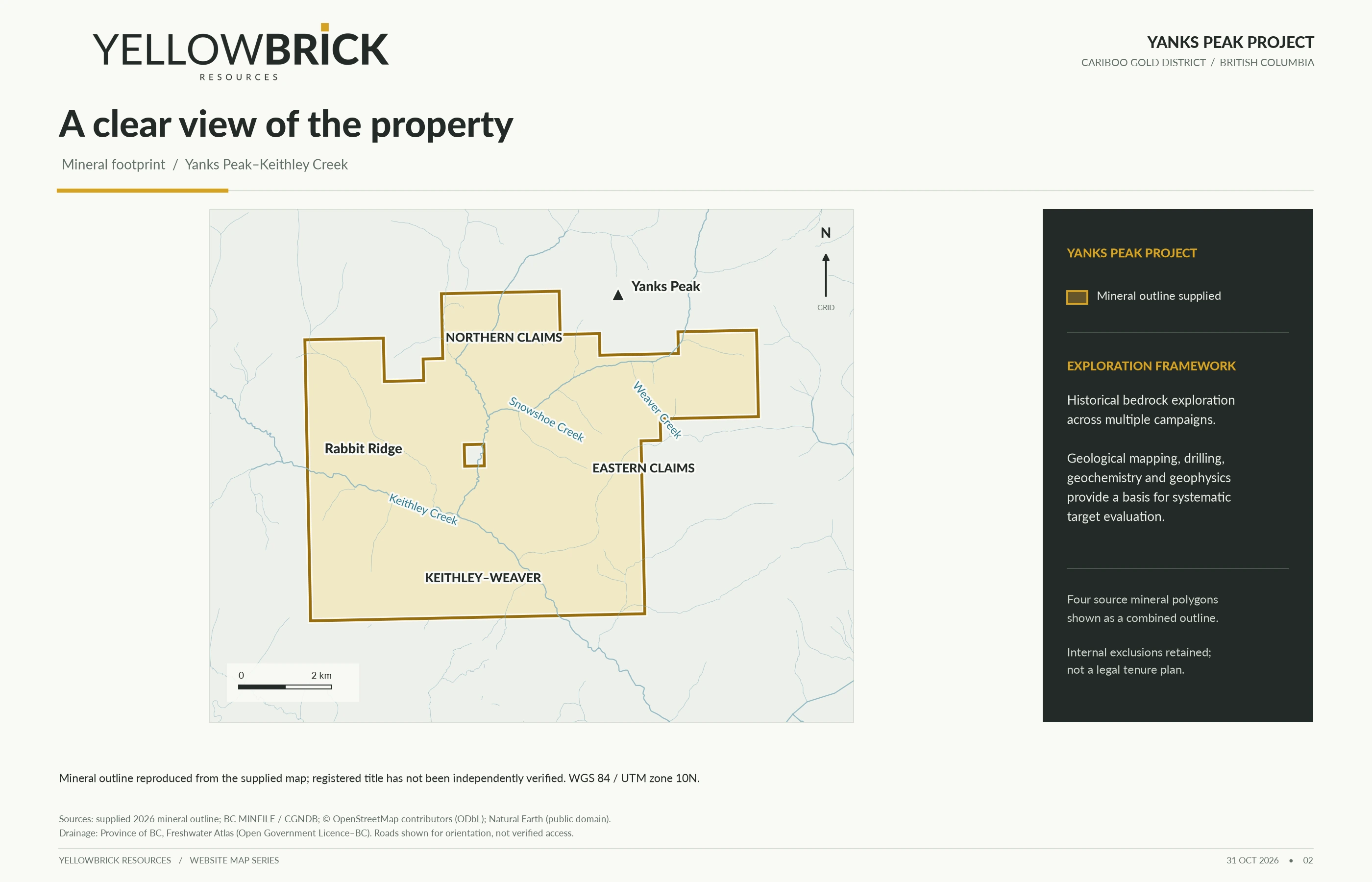
01 / Supplied mineral footprint
 Enlarge map ↗
Supplied 2026 geometry, including the internal exclusion. Not independent verification of title, rights or access.

A substantial historical record.
A focused bedrock-gold question.
The next chapter, built with a partner.
Property-option discussions—not a securities offering.
Public opportunity summary · 1 November 2026
Yellow Brick Resources is seeking an option partner to evaluate Yanks Peak and shape a disciplined exploration approach. The starting point is not a blank map: it is a body of historical work that can be reconciled, challenged and tested.
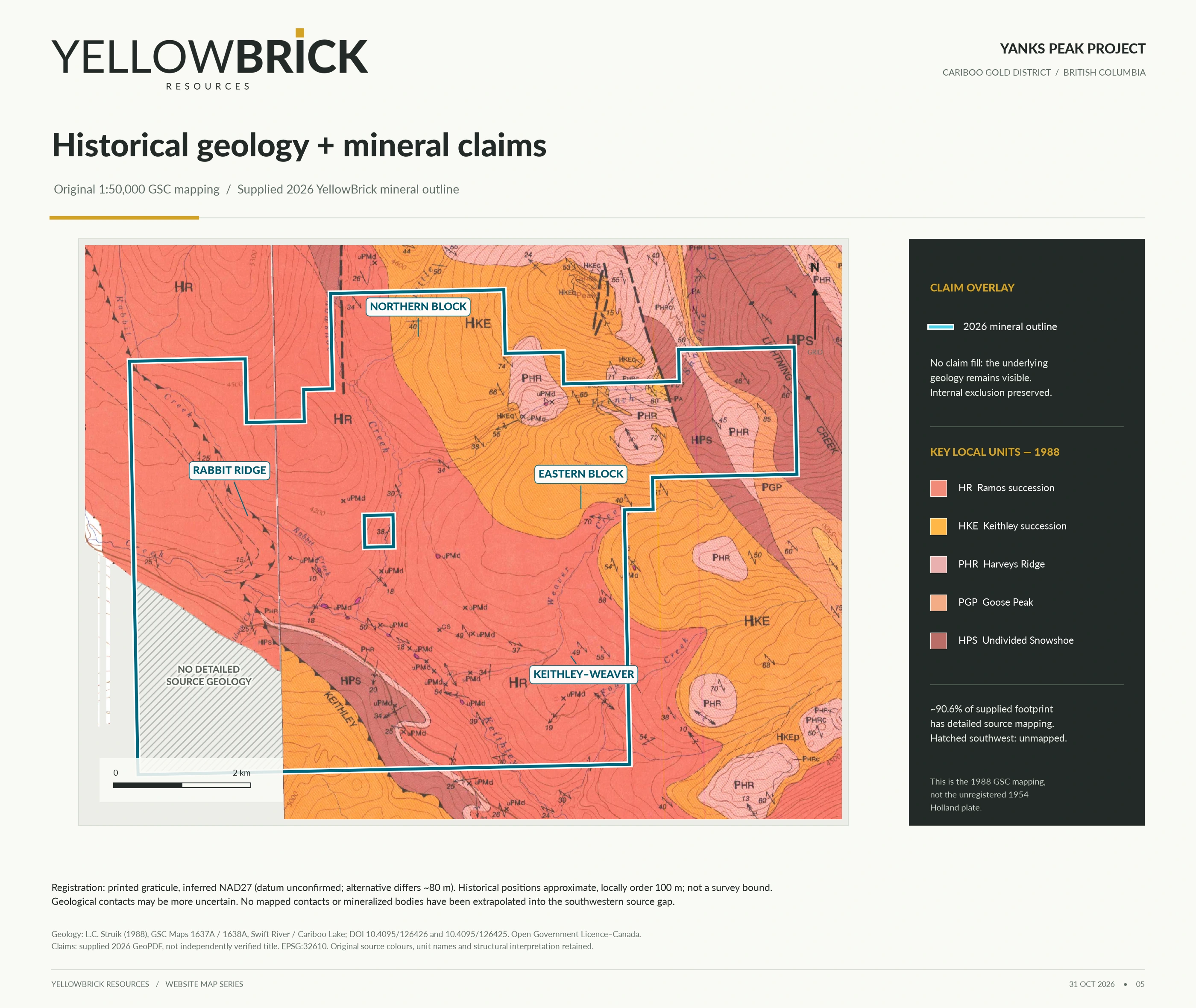
In the Barkerville Terrane, folded and faulted metasedimentary rocks, quartz–carbonate veins and contrasting rock contacts frame a bedrock-gold exploration thesis. The practical question is where mapped structures and contacts coincide with reliable geochemical and geophysical evidence. [1]
The 2018 survey interpretation identifies a northeastern composite magnetic, chargeability and resistivity feature as a possible sulphide-enriched intrusive body associated with magnetite and faulting. This is a geological hypothesis—not a confirmed intrusion or gold discovery. Graphite, barren sulphides and rock or fluid contrasts remain alternative explanations. [2]
Read the geological interpretation →Earlier operators’ programs offer a basis for review, not an inventory of work verified on current tenure. The figures below cover selected work across the wider historical property. They are not work completed by Yellow Brick Resources. [3]
Not an audited lifetime total or a current-claim collar inventory. Shared magnetic/VLF traverses are not additional ground; line-kilometres are not property area. The revision-2 campaign ledger cited by the revision-3 copy was not included in the website package.
The 1990 drilling encountered graphite and sulphides relevant to electrical responses; selected core remained unassayed when reported. Reviewed 2005 core summaries reported low gold values. A credible reinterpretation must retain these constraints, not only the anomalies. [1]
No mineral resource or mineral reserve is stated here. Historical records and map responses are not a current economic study, a demonstration of continuity or a prediction of commercial discovery. Nearby occurrences and historical placer production are not project results.
Open the key maps on this page, then download the complete originals with their legends and qualifications. These are public review materials—not a claim that a private data room or complete technical archive is available.
Enlarge map ↗Supplied 2026 geometry, including the internal exclusion. Not independent verification of title, rights or access.
 Enlarge map · zoom and pan ↗
Selected reading: ARIS 37933 (2018 surveys; report 2019), ARIS 21523 (1990 drilling), ARIS 28442 (2005 drilling). The public record does not establish availability of original digital survey data, core, complete assays or a verified drill database.
The objective is an option agreement with a partner able to bring technical capability and exploration funding to a staged evaluation of Yanks Peak.
An option can provide a contractual route to acquire or earn an interest in a mineral project by satisfying agreed conditions. The interest, consideration and obligations depend on the negotiated agreement; this page does not grant any rights or set binding terms.
No price, interest percentage, royalty, cash payment, work commitment, exclusivity or transaction timetable is offered here. All terms remain to be negotiated, subject to verification, appropriate approvals and definitive documentation. No completed agreement is announced.
A practical discussion framework for a prospective partner. These are conceptual workstreams, not an approved, funded or permitted exploration program, and no sequence or schedule is committed.
Verify claim identifiers, standing, registered interests, encumbrances and authority to transact. Reconcile mineral versus placer rights, surface access, applicable permits and engagement requirements.
Locate historical collars, grids and samples relative to verified tenure. Review logs, assays, QA/QC, coordinate systems, missing records and the limits of source-map registration.
Consider mapping, site relocation and documented sampling where justified. Reassess competing explanations before designing further geophysics or drilling.
Use independent professional review to define justified work, costs, responsibilities and decision criteria. Progress only with appropriate funding, authorizations and agreed documentation.
Historical work may fall outside applicable current rights; original datasets may be incomplete or unavailable. Map registration and source scales limit positional confidence. Geophysical responses are non-unique, and geological targets may not contain economic mineralization. Access, seasonality, environmental obligations, Indigenous engagement, permits and funding may constrain or prevent work. An option transaction or successful exploration outcome is not assured.
Prospective partners should obtain independent geological, legal, environmental and commercial advice. This summary does not assert qualified-person approval, technical-disclosure compliance or legal certification. Read the website’s information limitations →
No. The opportunity presented is a proposed property-option relationship for an exploration partner. This page is not a securities offering, capital raise or promise of investment returns.
No. Commercial terms and the scope of any interest would be negotiated after due diligence and documented in a definitive agreement. Nothing here confirms ownership, exclusivity or a right to acquire the property.
The public index above links complete source maps, the reference atlas, historical report records and the exploration chronology. No private data room is represented as ready, and no availability of additional records or physical core is promised.
Not necessarily. They summarize selected programs across the wider historical property. Collar positions, survey coverage and applicable rights still need reconciliation; they are not a verified current-claim inventory.
No mineral resource or reserve is stated here. Historical material is not a current economic study. The review pathway is conceptual and does not announce approved, funded or permitted fieldwork.
Review the public materials and note your technical questions, relevant experience and preferred transaction approach for a future discussion. The website enquiry service is currently unavailable; no information is collected or message sent on this page.
Download the brief, inspect the source maps and identify the questions that would matter to your team’s initial assessment.
No message can be submitted through this website at present. Public materials remain accessible; this page does not collect your details.